


Mobile Topographer GIS


Опис програми Mobile Topographer GIS
Улюблений вибір професіоналів, Mobile топограф ... відповідає ... ГІС .
Тепер ви можете виконати повне обстеження без будь-яких обмежень Into складності або об'єму даних.
Спробувати Mobile топограф ГІС з використанням трьох днів безкоштовного ознайомчого періоду. Просто скачайте додаток і продовжити процедуру підписки він. Хоча, вам буде запропоновано надати платіжну інформацію, ви не будете платити до кінця трьох днів безкоштовного пробного періоду. Ви можете скасувати підписку в будь-який час протягом трьох днів випробувального терміну безкоштовно. Звинувачення відбуватимуться тільки, якщо в кінці трьох днів ви все ще є активні підписки.
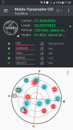
- Збір GNSS показань з використанням підвищеної точності (GPS, ГЛОНАСС, Galileo, Beidou, QZSS підтримуються сузір'я).
- Підключіть зовнішній GNSS приймач за допомогою фіктивних місць розташування та використовувати мобільний Topogrpaher ГІС в якості блоку обробки.
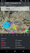
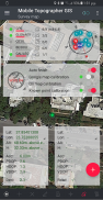
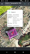
- Відображення даних в WGS84 або місцевий проектованих CRS.
- Перетворення з WGS84 в місцевий проектується CRS і навпаки.
- в режимі реального часу проекція на карті.
- *** NEW *** Користувальницькі зображення або сервер WMS в якості фону карти.
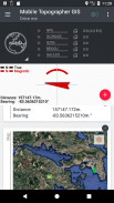
- Знайти зазначену точку в реальному світі за допомогою «Відвезіть мене»
- висота Обчислити ортометричною на льоту з використанням моделі Воса або локальних мереж висот якщо такі є.
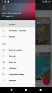
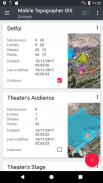
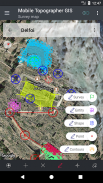
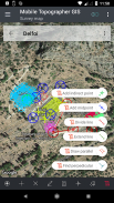
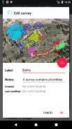
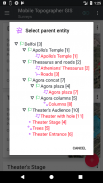
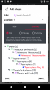
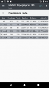
- організувати роботу в окуляри - Shapes - суб'єкти і обстеження. Тепер ви можете створити окремі точки, багатоточкові групи, багатокомпонентні полилинии і багатокомпонентні багатокутники з отворами.
- Створення повного малюнка з такою великою кількістю деталей, як ви хочете.
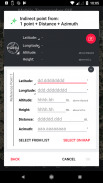
- *** NEW *** геодезичні інструменти. Додати непрямі точки за допомогою одного з таких варіантів: 1 пункт + Відстань + Азимут, 2 очка + Відстані + Вибрати, 2 бали + азимутах, 3 очка + Відстані, Midpoint лінії, Divide лінії, подовжує лінія, паралельна лінія, перпендикулярна прямий ,
- Гнізда свої робочі місця, в будь-якого ступеня вкладеності, щоб створити супер-опитування.
- Обмін даними між робочими місцями з активними посиланнями.
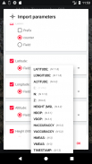
- Обмін завдання між мобільним пристроєм і настільним комп'ютером, з імпортом - експорт функціями, використовуючи всі розповсюджені формати .txt, .csv, .kml, .gpx, .dxf і Shape-файли (.shp - .shx - .dbf)
- Співпрацювати з вашими партнерами шляхом обміну і спільного використання з однієї точки, щоб закінчити роботу.
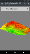
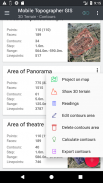
- Створення 3D-рельєф області, просто прогулюючись по ньому.
- Обчислити контури і додати їх в свій опитування з блискавичною швидкістю.
- Перегляд в реальному 3D моделі безпосередньо в пристрій.
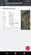
- Збереження маршруту з його даними.
- Показати GNSS супутники з інформацією сигналу в обох компаса або AR.
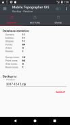
- Створення резервних копій та відновлення даних за допомогою файлу SQL .db.
Ласкаво просимо в еру мобільного зйомки ...!
Дізнайтеся більше про мобільному топограф ГІС в:
http://applicality.com/projects/mobile-topographer-gis/
Завантажити керівництво користувача від:
http://applicality.com/app_documentation/web/MobileTopographerGIS_Manual.pdf


Mobile Topographer GIS - інформація про APK
Версія APK: 6.0.15ID пакета: com.applicality.mobiletopographergisОстання версія Mobile Topographer GIS
Інші версії


 4.34
4.34


Додатки в цій категорії

Вам також може сподобатися...


